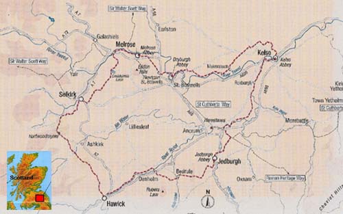
Abbeys Walk
The 64.5 mile / 103 Km walk was developed around the four ruined Border
Abbeys and the location of an even earlier but short lived Tironsian
Abbey in Selkirk. Although all four are now in ruin they are beautiful
monuments to the many Cistercian and Augustinian monks who lived here
in the 12th to 16th centuries.
|
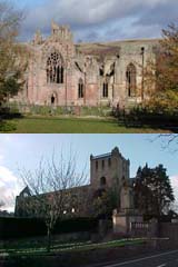
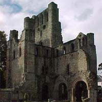
Kelso Abbey
Founder in 1128 when Prince David granted the land to the
Tyronensian Cistercian monks, this was seen as a more appropriate site to
the earlier Abbey of 1113 set up in Selkirk.
This was perhaps the largest of the Border Abbeys although
its distruction in 1545 left very limited remains.
|
|
|
|
|
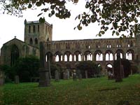
Jedburgh Abbey
This was first established as a Priory for the Augustinian
Canons but in 1154 King David I granted it Abbey status.
This Abbey was used for the Royal Concecration of Alexander III's marriage in 1285. Like Kelso Abbey it
was burnt by the Earl of Hertford in 1545.
|
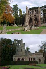
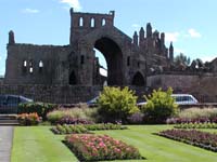
Melrose Abbey
King David granted the land and charter in 1136 to the
Cistercian monks from Rievaulx.
This was to become a very wealthy monastery but it was completely
destroyed by Richard II in 1385. What now exists was the 15th Century
Gothic Abbey that replaced the earlier monastery.
|
|
|
|
|
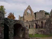
Dryburgh Abbey
Established in 1150 for the Augustinian Monks from
Premonstre in France this was a smaller Abbey to the others.
Its fate was similar with it being burnt in 1322 by Edward II and in 1385 by Richard II. It was finally
attacked and abandoned in 1544.
|
|
Link to the History and Interest
section for a fuller understanding of the history of the Border
Abbeys.
The following table provides details of the recommended day sections,
although it is recognised that some walkers may want to extend the
distances and hence reduce the walk from five days to four.
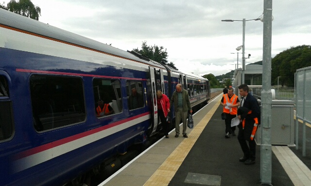
With the re-opening of the Border Railway even further options are
now available with the potential to start and end the route at the
Tweedbank Railway Station, only a few hundred yards from the waymarked
route.
Click on the above image to access information on what support can be offered to walkers thinking of using the
railways as a means of accessing the Borders Abbeys Way.
|
Section |
Distance Miles/KM |
Start & End Elevation |
Highest points |
Kelso-Jedburgh |
12/19 |
134 & 280 ft |
390 ft |
Jedburgh-Hawick |
12.5/20 |
280 & 344 ft |
985 & 563 ft |
Hawick-Selkirk |
12.5/20 |
344 & 564 ft |
999 & 1113 ft |
Selkirk-Melrose |
10/16 |
564 & 320 ft |
880 ft |
Melrose-Kelso |
17.5/28 |
320 & 134 ft |
485 ft |
Complete
walk |
64.5/103 |
|
1113 ft |
|
For alternative options including the Tweedbank starting point and fuller details on
walking terrain link to the Walker's Details section.
This is a fully waymarked route, however we would recommend that it is walked with appropriate Ordnance Survey maps. If you are
looking for detailed directions for all key junctions Walking Support is able to provide a detailed junction by junction grid
referenced instruction for a nominal sum of £3.99. Simply click on the Buy Now button and once on line payment has been
confirmed Walking Support will send you by an e-mail attachment the O/S grid reference data.
For a detailed look at each of the sections click on the appropriate
section of the map or on the section links below.
|
|
|
|
|